Why Storm Mergers Are Your Key to Chasing Tornadoes
Why Storm Mergers Are Your Key to Chasing Tornadoes
June 2025
As a longtime storm chaser, I used to believe that an isolated supercell with unimpeded inflow was ideal for tornado formation. Too many storms nearby, I thought, would disrupt the process. But after years of chasing, I noticed something surprising: tornadoes often formed just minutes after storms merged. A chaotic cluster of storms could transform into a powerful supercell post-merger. This led me to dig into the research—and the findings were eye-opening.
Recent studies show that storm mergers are frequently linked to tornado formation. One study found that about half of supercells produce their first tornado after merging with another storm (Rogers and Weiss, 2008). However, not all mergers lead to tornadoes. Today, I’ll break down four types of mergers commonly associated with tornadoes, based on recent research, and share four practical applications for storm chasers:
- Target supercells with southwest flank storms
- Beware of forward-flank mergers
- Focus on favorable environments
- Stay flexible with your target
Understanding these dynamics can help you pick the right storm, know when to switch targets, or reposition for safety.
Most chasers don’t fully grasp how storm mergers influence tornadoes, which can lead to poor decisions in the field. I’ve been there myself.
A Lesson from the Field: May 1, 2018
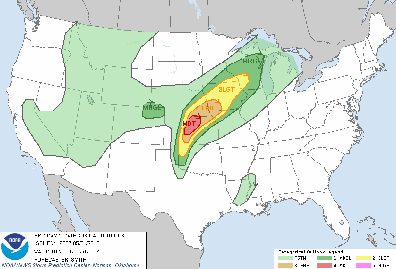
On May 1, 2018, the Storm Prediction Center issued a Moderate risk for severe weather in northern Kansas, highlighting the potential for strong to violent tornadoes. My team positioned in Russell, KS, right in the heart of the target area. Storms were firing all around, and a tornado watch was issued by 3 p.m. local time.
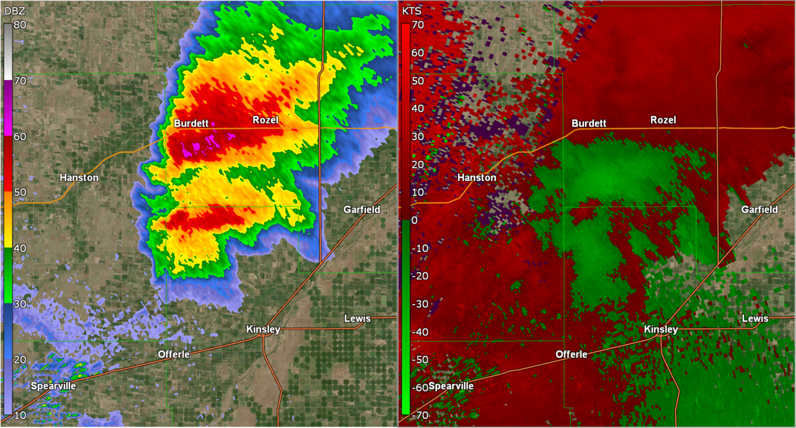
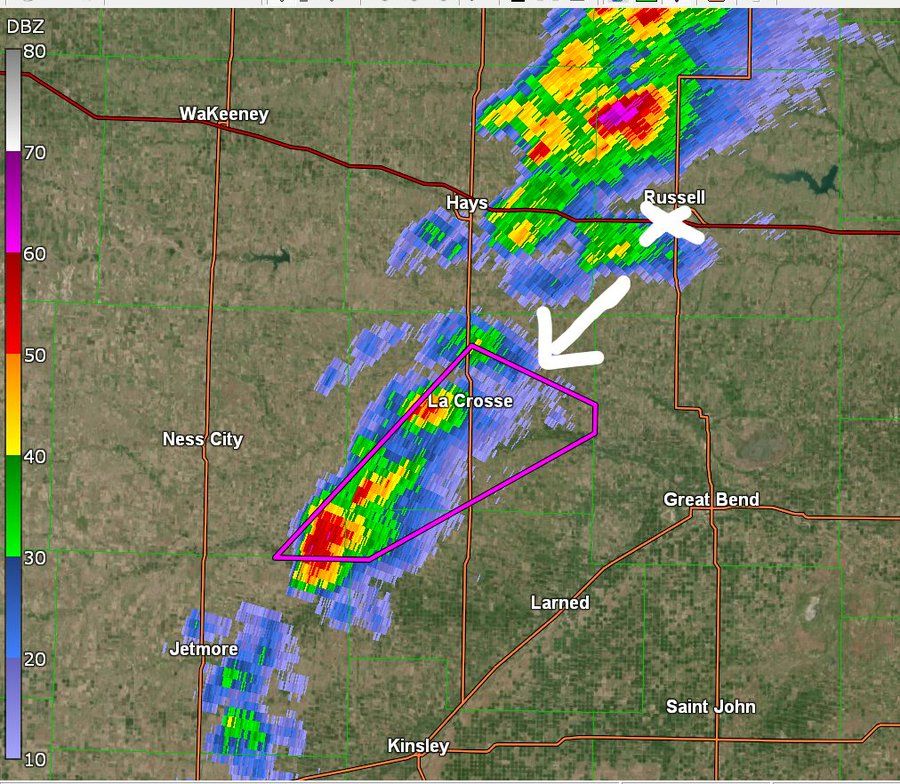
A storm formed between Jetmore and La Crosse, KS, and quickly earned a tornado warning due to a reported landspout. The environment was primed for significant tornadoes, so we moved west of Hoisington to intercept. Initially, the storm looked promising—textbook supercell structure, and I was convinced a big tornado was imminent.
 But soon, the storm began to falter. I blamed the crowded storm environment, thinking too many nearby storms were choking its inflow. Meanwhile, to the south, a pristine, isolated supercell near Kinsley was tornado-warned. It looked perfect, so we abandoned our original target and raced south—only to watch the Kinsley storm weaken dramatically.
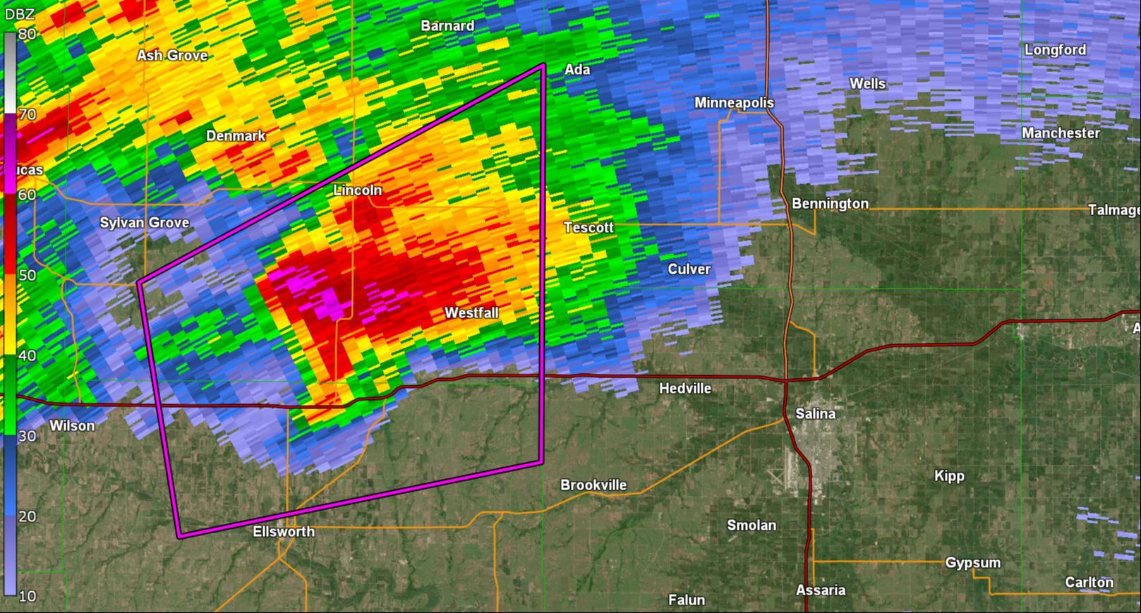
Back north, the “messy” cluster of storms we’d left behind had merged, forming a monster supercell. Near Tescott, just 45 miles from our original position, it produced a large, strong tornado. That miss stung. Had we understood the power of storm mergers, we might have stuck with our initial target.
What Research Says About Storm Mergers
A 2023 study by Fischer and Dahl found that 80% of supercell tornadoes involve interactions with other storms beforehand. Most of these interactions occur just upstream of the hook echo, in the southwestern quadrant of the supercell. The study identified four merger scenarios linked to tornado formation:
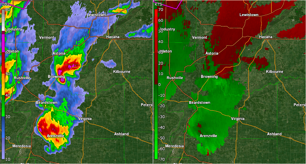
- Chain of Supercells: A southern supercell “pumps” outflow into a northern tornadic cell. Example: Havana, IL, December 1, 2018.
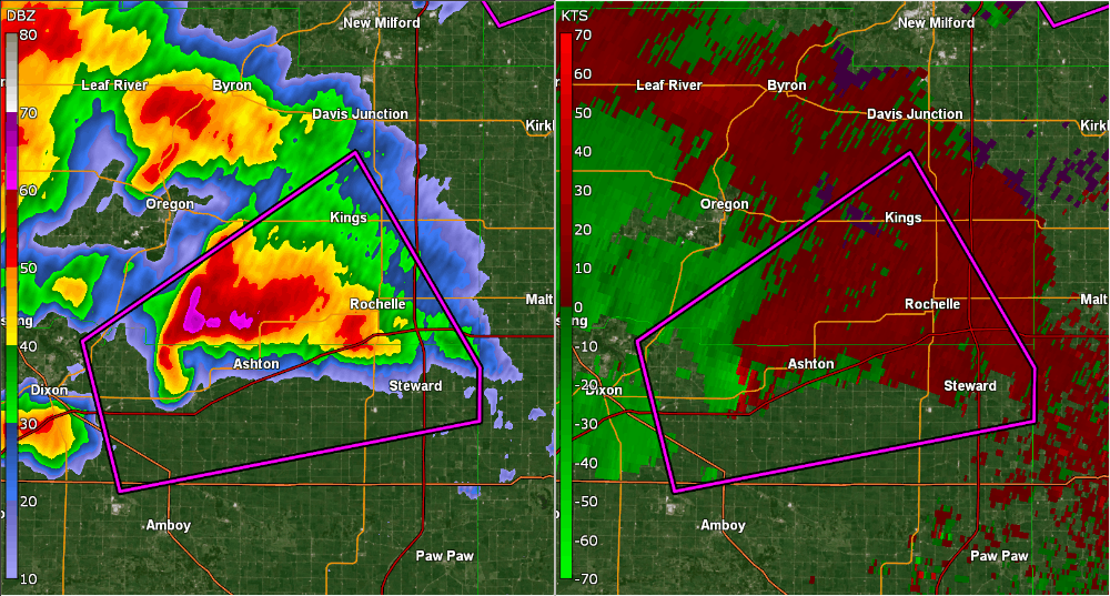
- QLCS or Outflow Boundary Impact: A quasi-linear convective system or outflow boundary hits a supercell from the west. Example: Rochelle, IL, April 9, 2015, where outflow likely influenced tornadogenesis.
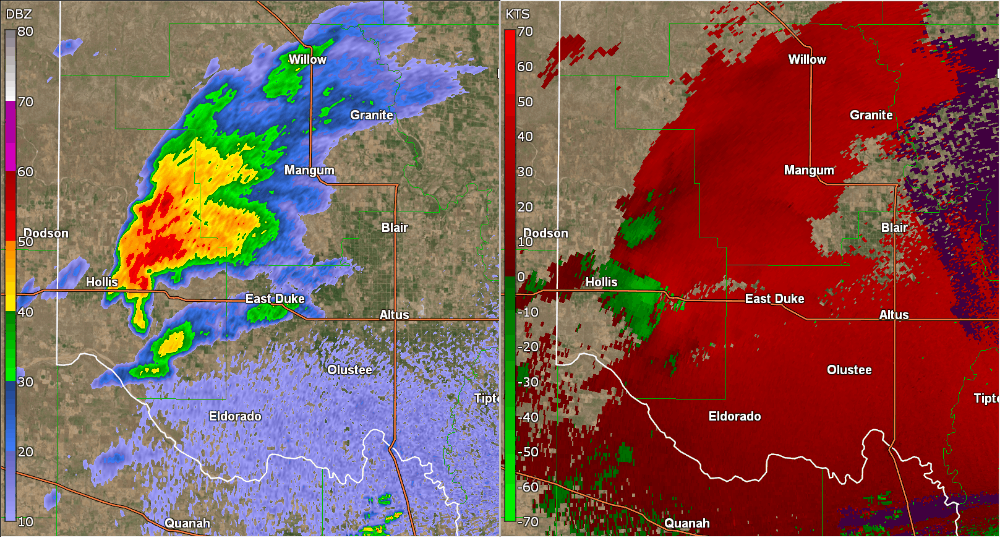
- Discrete Storm Merger: A smaller storm merges with a supercell’s inflow region before or during tornado formation. Example: Mangum, OK, May 20, 2019.
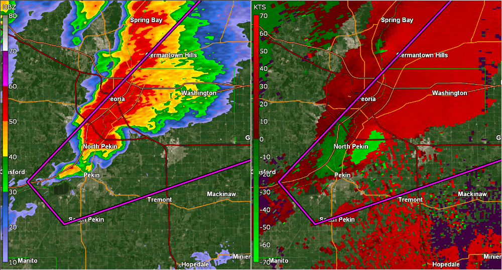
- Flanking Line Convection: Storms along a supercell’s flanking line produce outflow that impacts the supercell. Example: Washington, IL, November 17, 2013.
Why Do Mergers Matter?
Fischer and Dahl propose that external outflow from merging storms slows the movement of circulations behind the supercell, keeping them under the updraft longer. This allows the updraft to stretch the circulation into a tornado.
Further supporting this, a 2024 study by Cameron Nixon and collaborators found that tornadic storms often have more storms in their rear flanks than their forward flanks. In contrast, large hail is more common with forward-flank mergers. Rear-flank mergers are most effective in environments with strong storm-relative inflow and low lifting condensation levels (LCLs)—meaning low cloud bases and significant wind shear near the ground.
Applications for Storm Chasers
- Target Supercells with Southwest Flank Storms: Research consistently shows that supercells with smaller storms in their southwestern quadrant are more likely to produce tornadoes.
- Beware of Forward-Flank Mergers: These are more likely to produce large hail than tornadoes.
- Focus on Favorable Environments: Prioritize areas with strong storm-relative inflow and low LCLs, as these conditions favor rear-flank storm interactions that lead to tornadoes.
- Stay Flexible with Your Target: If your target storm looks messy but has nearby storms in the right position, give it time—mergers can quickly turn a struggling storm into a tornadic powerhouse.
By understanding storm mergers, chasers can make smarter decisions, avoid costly mistakes, and stay safer in the field.

If you’re looking to deepen your tornado chasing skills, The Tornado Chaser Transformation is available now. This 6-hour course distills my years of experience—meteorology, chasing techniques, and safety insights—to guide you further, whether you’re just starting or seeking to refine your craft. Find it here whenever you’re ready to explore more.
