Does History Repeat Itself? Comparing Two Plains Tornado Outbreaks
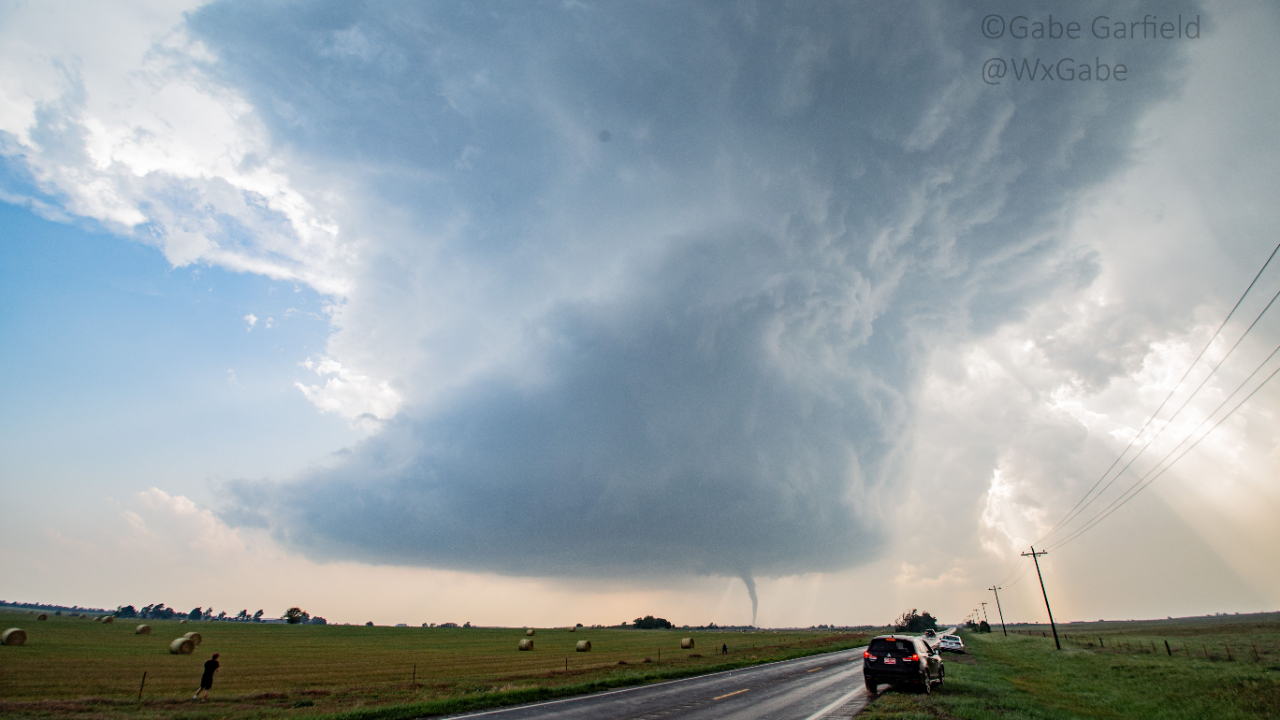
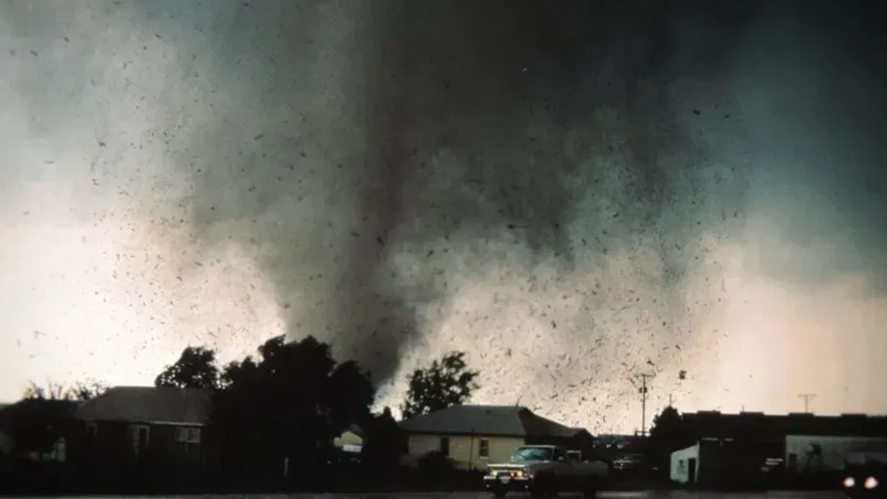
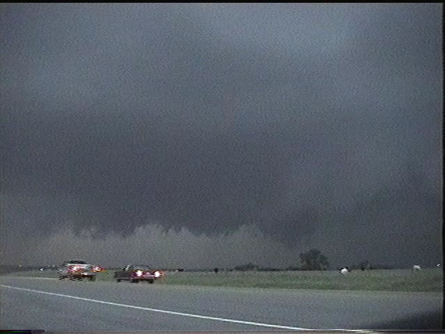
On May 4, 2007, one of the most infamous tornado events in storm-chasing history unfolded in Kansas. The small town of Greensburg was devastated by a nearly two-mile-wide tornado, destroying 90% of the town.

This was the first tornado rated EF5 on the Enhanced Fujita scale. It killed 12 people and injured 63. From a chaser's perspective, the event's most remarkable feature was the sheer number of large, violent tornadoes produced by the parent supercell.
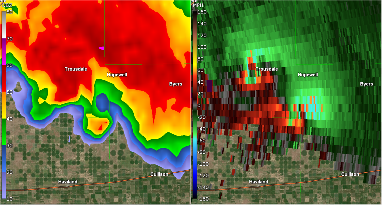
After striking Greensburg, the storm spawned three more massive tornadoes, two of which—the Trousdale and Hopewell wedges—occurred simultaneously. The Trousdale tornado reached 2.2 miles wide, while Hopewell was 1.2 miles wide. For comparison, even the violent Pilger twin tornadoes on June 16, 2014, paled in scale next to this pair. In total, the storm produced at least 22 tornadoes over six hours.
To me, this was one of the greatest supercells of all time. While there may have been larger outbreaks, the Greensburg storm stood u...
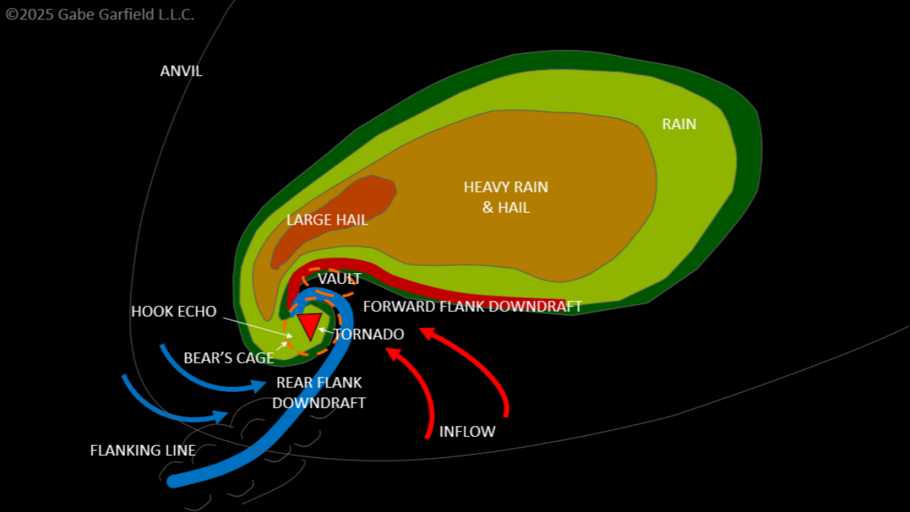
Lofted Cars Reveal Extreme Tornado Intensities
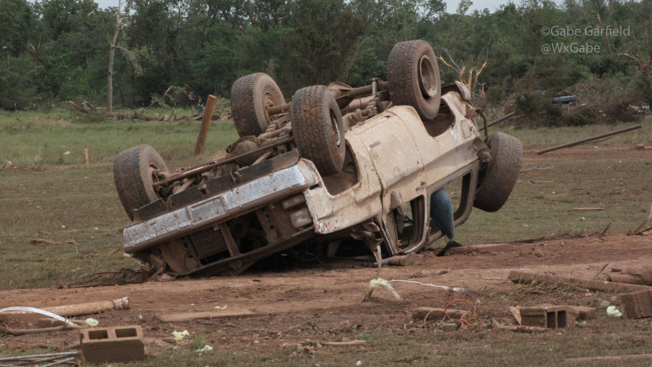
In a recent peer-reviewed paper, Canadian scientists quietly released some astonishing findings from their tornado research. They concluded that vehicles lofted more than 50 meters are typically hurled by EF-5 intensity winds. I'm betting you're like me when you first read that: a bit skeptical. How on earth did they reach that verdict?
I was curious too, so I dove into the 2024 study by Connell Miller and his collaborators, titled "Estimating Wind Speeds in Tornadoes Using Debris Trajectories of Large Compact Objects." What I uncovered blew me away. Today, I'll unpack their work and explain why tornadoes pack more punch than you might realize.
Why This Matters to Storm Chasers
Okay, that's intriguing. But as a chaser, why does it matter to me? Simply, it directly impacts the risks we accept. As you know, chasers are edging ever closer to tornadoes these days. Social media rewards that boldness with views. This shrinks our safety buffer, raising the odds that we'll get caught in the...
The 5 Chase Modes: Secrets to Picking the Best Storm View
What if you could choose what kind of experience you want while storm chasing – incredible close-ups of the funnel, beautiful storm structure shots, or a safe view – without guessing where to go?
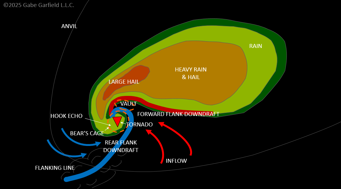
Today, we’re talking about the five modes of tornado chasing: Traditional Chasing, Structure Chasing, Hook Slicing, Notch Chasing, and Close Ranging and how to pick the perfect spot for your next storm chase.
It’s like choosing your seat at movie theater: some like to get the fully immersive experience up front, while others like to stay back and get the full picture. Tornado chasing is the same – some prefer wild experiences near the tornado, like Reed Timmer. Others prefer to get majestic shots of the storm’s full structure. Your position depends on what your chasing goals are.
Many new chasers think they’re stuck with whatever spot they get. The truth? Most of the time, you can choose. It’s usually possible to maneuver around the storm to get the experience you want. You just have to p...
Why Storm Mergers Are Your Key to Chasing Tornadoes
Why Storm Mergers Are Your Key to Chasing Tornadoes
June 2025
As a longtime storm chaser, I used to believe that an isolated supercell with unimpeded inflow was ideal for tornado formation. Too many storms nearby, I thought, would disrupt the process. But after years of chasing, I noticed something surprising: tornadoes often formed just minutes after storms merged. A chaotic cluster of storms could transform into a powerful supercell post-merger. This led me to dig into the research—and the findings were eye-opening.
Recent studies show that storm mergers are frequently linked to tornado formation. One study found that about half of supercells produce their first tornado after merging with another storm (Rogers and Weiss, 2008). However, not all mergers lead to tornadoes. Today, I’ll break down four types of mergers commonly associated with tornadoes, based on recent research, and share four practical applications for storm chasers:
- Target supercells with southwest flank storms ...
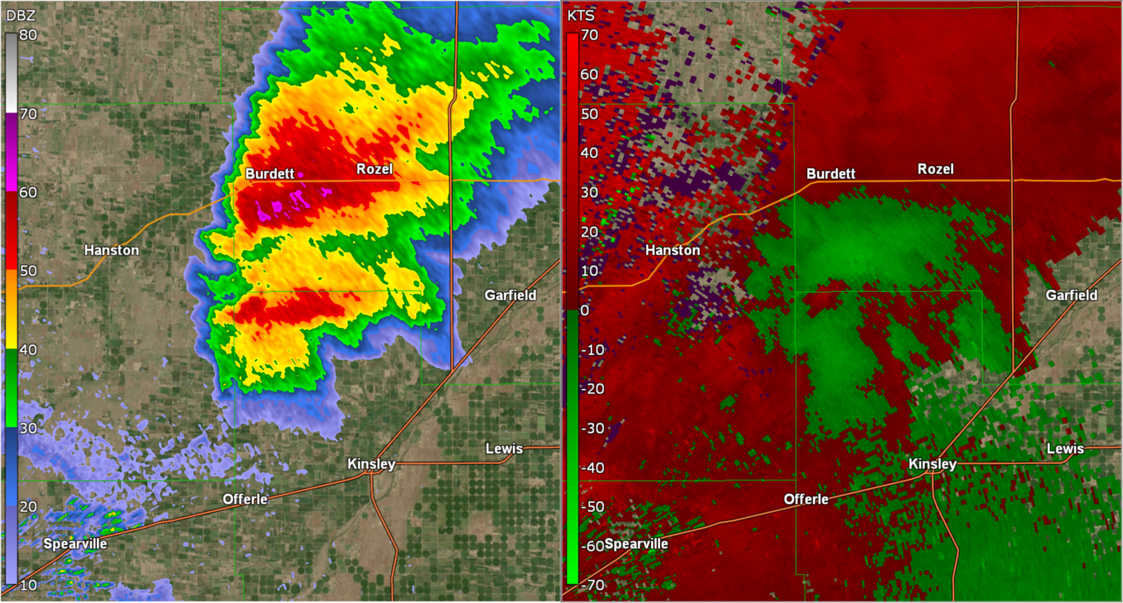
What Fuels Monster Tornadoes? Insights from a Historic Outbreak
Today, I’ll explain the three critical atmospheric conditions that drive violent tornado outbreaks.
For storm chasers, recognizing these signs is a call to action—you’ll want to hit the road immediately. While many focus on strong winds at all atmospheric levels and an incoming short-wave trough, one of the most destructive tornado outbreaks in history, featuring at least four potentially F5-strength tornadoes capable of scouring vegetation, stripping asphalt, and obliterating the ground, had subtler signals.
What You’ll Learn: The Three Key Features
- Moderate mid-level flow
- Strong low-level flow
- Extreme instability
But first, let’s revisit one of the most iconic tornado outbreaks in storm chasing history: the June 8, 1995, Texas Panhandle outbreak.
The June 8, 1995, Texas Panhandle Tornado Outbreak
This outbreak ranks among the most memorable in the storm chasing era, a dream chase that calls for a time machine. With 29 tornadoes across the Texas Panhandle and western Oklah...
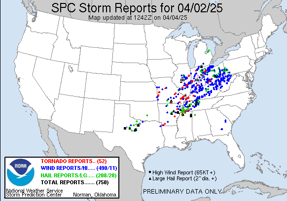
Major Tornado Outbreak Ravages Central United States: Why It Happened
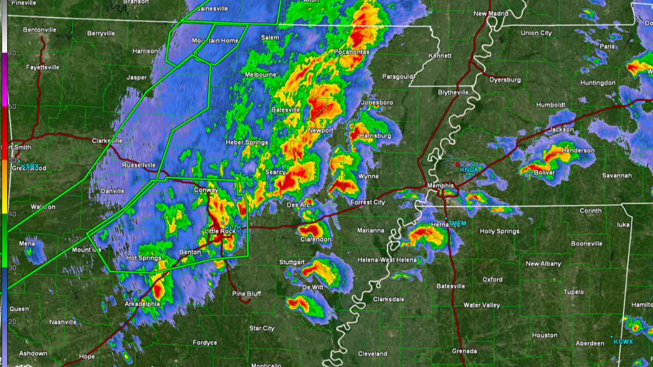
On April 2, 2025, a massive outbreak of tornadoes ravaged the middle Mississippi and Ohio Valley regions, impacting at least eight states from Arkansas to Ohio. Storm chaser Brandon Copic captured live video of a strikingly powerful and visible wedge tornado near Lake City in northeast Arkansas, which many viewers witnessed. Tragically, the tornadoes claimed at least six lives across the affected areas.
The evening before the tornado outbreak, many storm chasers doubted a significant event would unfold. High-resolution weather models suggested a widespread squall line with embedded supercells would develop, but few expected its intensity. Surprisingly, Chris Broyles, a veteran forecaster at the Storm Prediction Center, escalated the risk level to High.
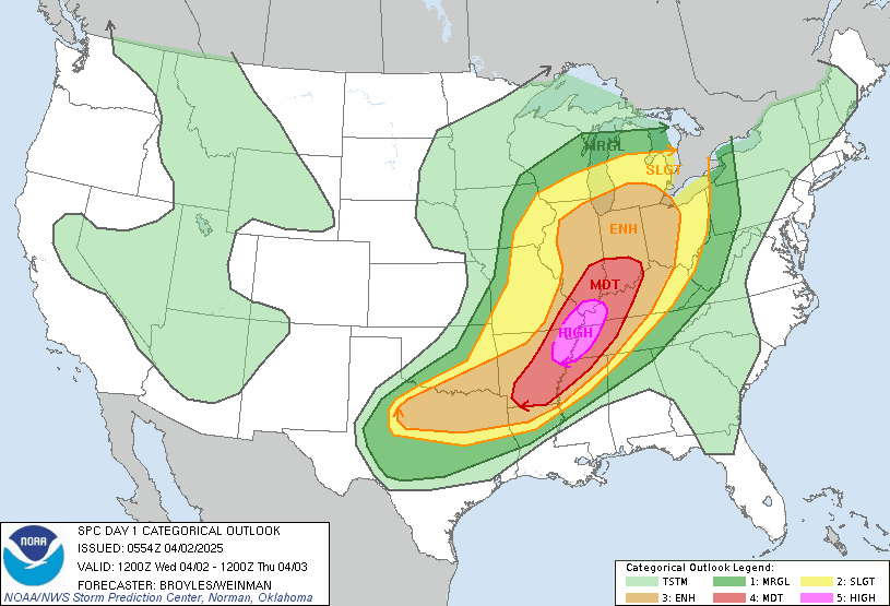
What was he seeing? What fueled his confidence? Although I haven’t discussed this with Chris yet, subtle clues hinted at a major event. Let’s explore why this outbreak became so explosive.
The Setup
The weather forecast for April...
From Beginner to Tornado Chaser: 3 Steps to Start Strong
Many people ask me, “Where can I learn how to chase storms?” It’s a great question, but if you look online, you won’t find a clear, straightforward answer. Most aspiring storm chasers have to piece together information from various sources and learn through trial and error in the field. While that hands-on approach can be rewarding, it often leads to mistakes—missing tornadoes or even getting into dangerous situations.
To help you get started more effectively, I’ve put together a simple plan to become a skilled tornado chaser as quickly as possible. Here are the three key steps:
- Build your knowledge and skills
- Prepare for the chase
- Start chasing storms
Before we dig into the details, let’s talk about why learning by trial and error can hold you back—and even put you in danger.
(Stay tuned for a big announcement at the end of this newsletter!)
The Pitfalls of Learning to Chase Storms by Trial and Error
I grew up in the Twister era of storm chasers, and I’ll be honest—it lit...
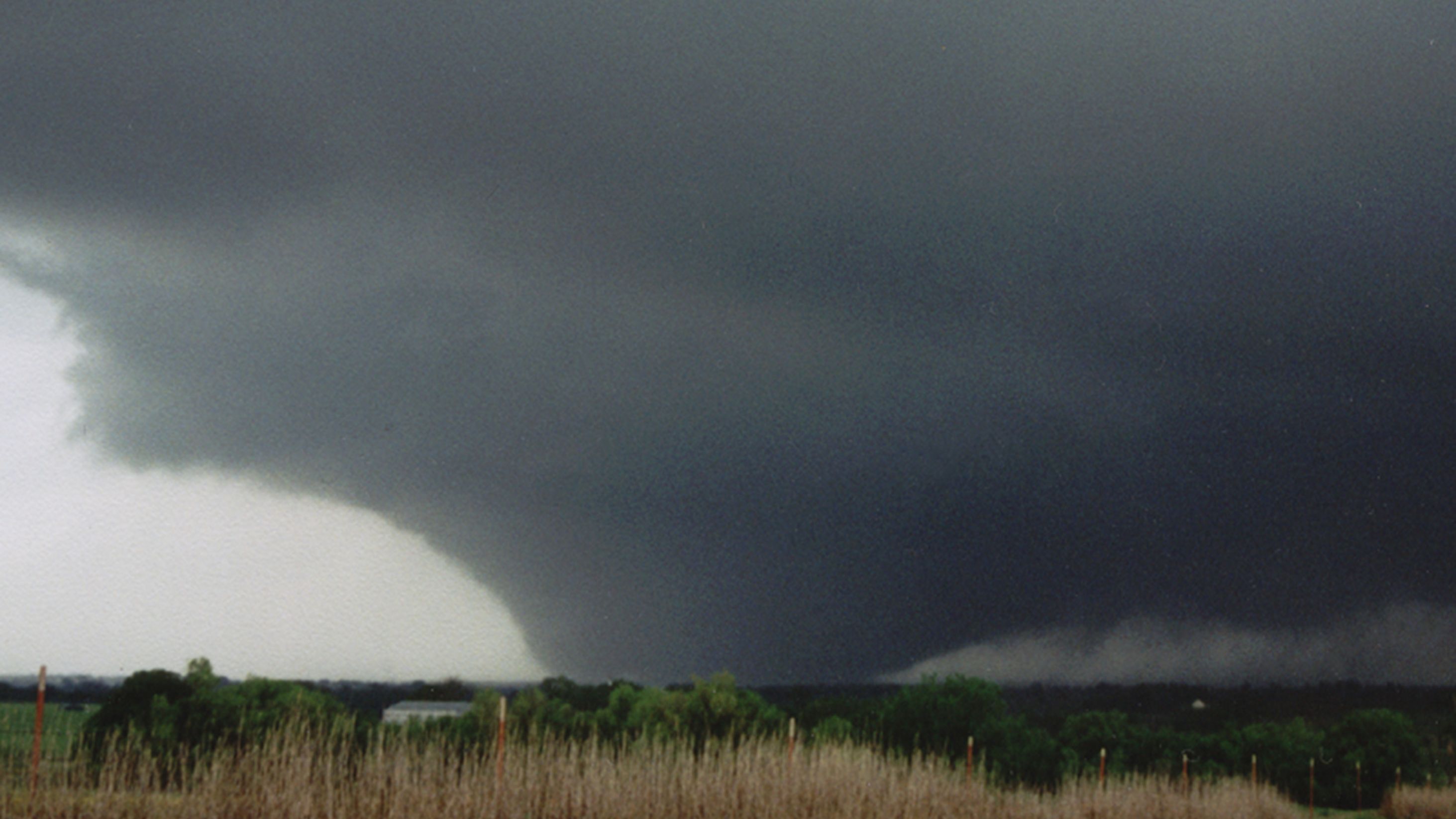
May 26, 2000 - Tornadic Supercell Near Binger, Oklahoma
This large supercell formed near Binger, Oklahoma on May 26, 2000. If I recall correctly, SBCAPE was over 5,000 j/kg that day!
May 6, 2001 - Supercell Near Norman, OK!
To aid the Chase Archive effort, I plan to add a few old chases.
Here's a supercell we saw just southwest of Norman, Oklahoma on May 6, 2001. It was briefly tornadic near Noble, Oklahoma. (I didn't see it, but I believe Shane Adams did.)
May 3, 1999 Tornado Outbreak: Key Chasing Insights
Today, I’m going to share key tornado chasing lessons from the May 3, 1999 tornado outbreak—one of the most intense in Southern Plains history:
- 10 tornadic storms
- 69 tornadoes total
- 4 violent tornadoes (F4/F5)
The most infamous was the Bridge Creek-Moore F5 in Oklahoma. On the ground for over an hour, it destroyed nearly everything in its path. At its peak, it was over a mile wide, with Doppler on Wheels recording wind speeds of 319 mph as it tore through Bridge Creek.
In the years that followed, storm chasers often speculated about “the next May 3rd.” And each time, of course they were wrong. Eventually, those comparisons faded.
To this day, we haven’t seen a setup quite like it. Everything had to come together just right. And if even one thing had been different, an outbreak may not have happened.
Because of this, many chasers view it as a once-in-a-lifetime event—a perfect storm unlikely to be repeated. And while that’s probably true, elements of this outbreak have happe...
