Does History Repeat Itself? Comparing Two Plains Tornado Outbreaks
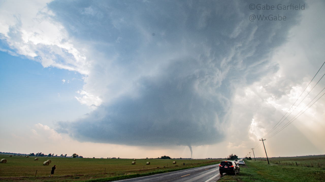
On May 4, 2007, one of the most infamous tornado events in storm-chasing history unfolded in Kansas. The small town of Greensburg was devastated by a nearly two-mile-wide tornado, destroying 90% of the town.

This was the first tornado rated EF5 on the Enhanced Fujita scale. It killed 12 people and injured 63. From a chaser's perspective, the event's most remarkable feature was the sheer number of large, violent tornadoes produced by the parent supercell.
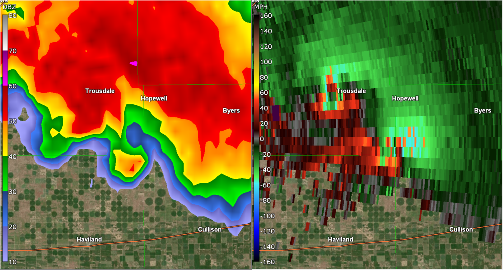
After striking Greensburg, the storm spawned three more massive tornadoes, two of which—the Trousdale and Hopewell wedges—occurred simultaneously. The Trousdale tornado reached 2.2 miles wide, while Hopewell was 1.2 miles wide. For comparison, even the violent Pilger twin tornadoes on June 16, 2014, paled in scale next to this pair. In total, the storm produced at least 22 tornadoes over six hours.
To me, this was one of the greatest supercells of all time. While there may have been larger outbreaks, the Greensburg storm stood u...
What Fuels Monster Tornadoes? Insights from a Historic Outbreak
Today, I’ll explain the three critical atmospheric conditions that drive violent tornado outbreaks.
For storm chasers, recognizing these signs is a call to action—you’ll want to hit the road immediately. While many focus on strong winds at all atmospheric levels and an incoming short-wave trough, one of the most destructive tornado outbreaks in history, featuring at least four potentially F5-strength tornadoes capable of scouring vegetation, stripping asphalt, and obliterating the ground, had subtler signals.
What You’ll Learn: The Three Key Features
- Moderate mid-level flow
- Strong low-level flow
- Extreme instability
But first, let’s revisit one of the most iconic tornado outbreaks in storm chasing history: the June 8, 1995, Texas Panhandle outbreak.
The June 8, 1995, Texas Panhandle Tornado Outbreak
This outbreak ranks among the most memorable in the storm chasing era, a dream chase that calls for a time machine. With 29 tornadoes across the Texas Panhandle and western Oklah...
May 3, 1999 Tornado Outbreak: Key Chasing Insights
Today, I’m going to share key tornado chasing lessons from the May 3, 1999 tornado outbreak—one of the most intense in Southern Plains history:
- 10 tornadic storms
- 69 tornadoes total
- 4 violent tornadoes (F4/F5)
The most infamous was the Bridge Creek-Moore F5 in Oklahoma. On the ground for over an hour, it destroyed nearly everything in its path. At its peak, it was over a mile wide, with Doppler on Wheels recording wind speeds of 319 mph as it tore through Bridge Creek.
In the years that followed, storm chasers often speculated about “the next May 3rd.” And each time, of course they were wrong. Eventually, those comparisons faded.
To this day, we haven’t seen a setup quite like it. Everything had to come together just right. And if even one thing had been different, an outbreak may not have happened.
Because of this, many chasers view it as a once-in-a-lifetime event—a perfect storm unlikely to be repeated. And while that’s probably true, elements of this outbreak have happe...
The Science Behind Long-Track Tornadoes: Lessons from the 2024 Houston-Port Arthur EF3

Long-track tornadoes, like the extraordinary December 28th, 2024 event in Southeast Texas, are among nature’s most incredible phenomena. Understanding what drives these rare storms isn’t just fascinating—it’s useful for storm chasers, meteorologists, and public safety. However, most people don’t realize the complex relationship between storm dynamics and tornado longevity.
In this post, you’ll discover:
- The key atmospheric conditions that enable tornadoes to travel long distances.
- The role of storm propagation in shaping the behavior of the Houston-Port Arthur storm.
- Practical strategies for intercepting tornadoes safely and effectively.
By the end, you’ll have practical insights into the mechanics of long-track tornadoes and how to apply them to real-world forecasting and storm chasing. Let’s dive into a summary of this rare atmospheric event.
Event Overview
On December 28th, 2024, an exceptionally long-lived tornado carved a path of destruction across Southeast Texas. Sta...
Scientists Confirm 300+ MPH Winds in Greenfield Tornado!

Scientists Confirm 300+ MPH Winds in Greenfield Tornado!
July 2024
Hello, Friend! Hope you're enjoying the weekend.
After an amazing severe weather season, we're finally enjoying some quiet in the Plains. So there's no better time to look back at one of the most intense tornadoes of the year!
GREENFIELD TORNADO MAX WINDS
Recently, the Center for Severe Weather Research confirmed that the EF4 Greenfield, Iowa tornado had some of the most intense winds ever observed. Based on Doppler on Wheels (DOWs) data, they estimate that the tornado contained winds of 309-318 mph!
As the 2024 #BEST field season ends, a glimpse into the data collection during the Greenfield, IA tornado. Peak wind speeds as high as 309-318 mph were calculated in a narrow region 100-160 feet ARL. These are among the highest wind speeds ever determined using DOW data. https://t.co/CM09J3VSOB pic.twitter.com/fuxfdyoi9d
— Doppler on Wheels (DOW) (@DOWFacility) June 22, 2024
These winds were measured near th...
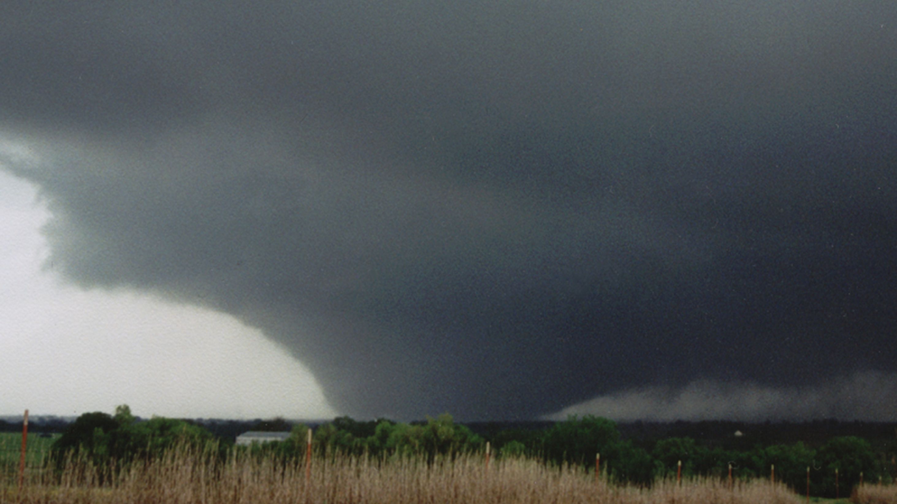
The Scariest Tornado I've Ever Chased - El Reno 2013
I’ve chased tornadoes for almost 25 years. And in that time, only one has ever chased me.
It was, of course, the El Reno, OK tornado of 5/31/13. It was 2.6 miles at its widest, had winds > 300 mph, and moved faster than 50 mph.
I’ve chased tornadoes for almost 25 years. And in that time, only one has ever chased me.
— Gabe Garfield (@WxGabe) February 11, 2024
It was, of course, the El Reno, OK tornado of 5/31/13.
It was 2.6 miles at its widest, had winds > 300 mph, and moved faster than 50 mph.
For the first time, here is my full story:
1/25 pic.twitter.com/7xuCcugP6L
To be honest, I really wasn't aware of how volatile it looked until it came. Reason being, the weather had been crazy. I'd been chasing more than a half-dozen times since May 18th. And frankly, I was exhausted. I wasn't very interested in forecasting.
But the day had arrived, and there was a lot of hype. So, obviously, I had to take a closer look. Extreme instability was a given over C OK. But the models now for...
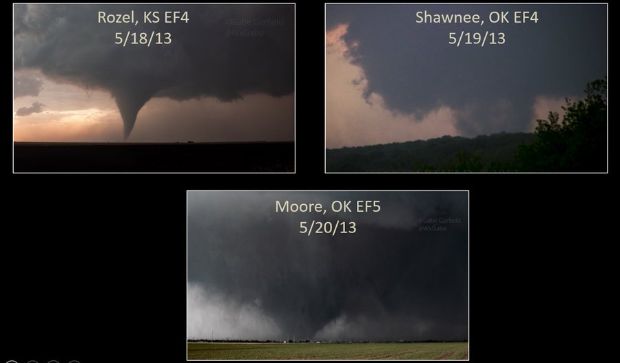
An Unforgettable Chase – The Moore EF5 Tornado (5/20/13)

Eleven years ago ago today, I had the most horrifying chase of my life.
That morning, I woke up late, in anticipation of a late start to my work day at the National Weather Center. Since it was a weekday, I wasn’t planning on chasing. Out of curiosity, though, I thought I would check out the forecast. While waiting for my computer to boot, I went outside to get a feel for the weather. It was sunny – but cool – and stratocumulus clouds were racing northward with the low-level jet. It just had the “feel” of a big day (most folks who have spent significant time in Tornado Alley know what I mean).
I went back inside to check out the forecast. After going through the usual parameter checking, I perused a few convection-allowing models (weather models that predict actual thunderstorms). An ominous forecast was projected: supercell thunderstorms would develop in central Oklahoma by mid-afternoon. I became increasingly concerned about the possibility of a significant tornado not far from Nor...
2024: Year of the Tornado
This has been an absolutely crazy week or so, hasn't it? And it looks like we're just getting started!
Check out Tomer Burg's animation of the last week's storm reports!
A quick look at SPC storm reports from the highly active - and unfortunately devastating - stretch of severe weather over the last week that is still ongoing: pic.twitter.com/YuyQWctk34
— Tomer Burg (@burgwx) May 4, 2024
THE YEAR OF THE TORNADO
Over the last several months, meteorologists had been suggesting that 2024 would be a big tornado year. A lot was made of the impact of high sea-surface temperatures in the Western Gulf of Mexico and the transition from El Nino to La Nina.
But as March rolled into April, below normal tornado activity continued. Several big events occurred, but photogenic tornadoes were few and far between.
One exception was a local outbreak of tornadoes that struck Iowa on April 16th. Paul Spomer caught this amazing, sinuous tornado just north of the surface low:
CAREER DAY in No
...
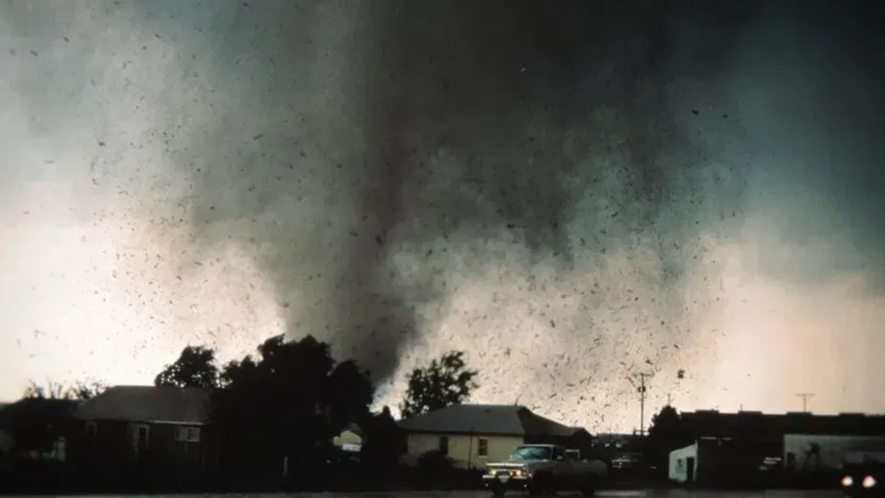
May 3, 1999 - A Day I Will Never Forget

May 3, 1999.
To those outside of Oklahoma, this date means very little. But to those Okies who survived the largest tornado outbreak in state history, “May 3rd” is forever branded into our collective conscious.
That day over 60 tornadoes swept across the Southern Plains, with the vast majority in central Oklahoma. Many of the tornadoes were strong, and at least 4 were violent (F4/F5).
Most people remember the Bridge Creek / Moore tornado, which until 2013 held the world record for highest wind speed on Earth (~300 mph). That tornado lasted well over an hour, and claimed the lives of over 30 people. Interestingly, that tornado was really only the beginning of the outbreak, as many more tornadoes occurred well after dark.
The most impressive of these was the Mulhall tornado, which was well over a mile in diameter; based on mobile radar data, it may have been more intense than the Moore tornado. The following is my story from that day.

It was early May in 1999, and I was f...
