What Fuels Monster Tornadoes? Insights from a Historic Outbreak
Today, I’ll explain the three critical atmospheric conditions that drive violent tornado outbreaks.
For storm chasers, recognizing these signs is a call to action—you’ll want to hit the road immediately. While many focus on strong winds at all atmospheric levels and an incoming short-wave trough, one of the most destructive tornado outbreaks in history, featuring at least four potentially F5-strength tornadoes capable of scouring vegetation, stripping asphalt, and obliterating the ground, had subtler signals.
What You’ll Learn: The Three Key Features
- Moderate mid-level flow
- Strong low-level flow
- Extreme instability
But first, let’s revisit one of the most iconic tornado outbreaks in storm chasing history: the June 8, 1995, Texas Panhandle outbreak.
The June 8, 1995, Texas Panhandle Tornado Outbreak
This outbreak ranks among the most memorable in the storm chasing era, a dream chase that calls for a time machine. With 29 tornadoes across the Texas Panhandle and western Oklahoma, the event unfolded in ideal chase terrain with minimal infrastructure to damage. Four tornadoes stood out, earning legendary status in the chasing community.
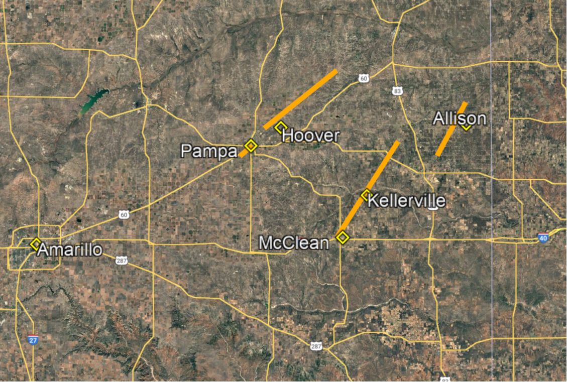
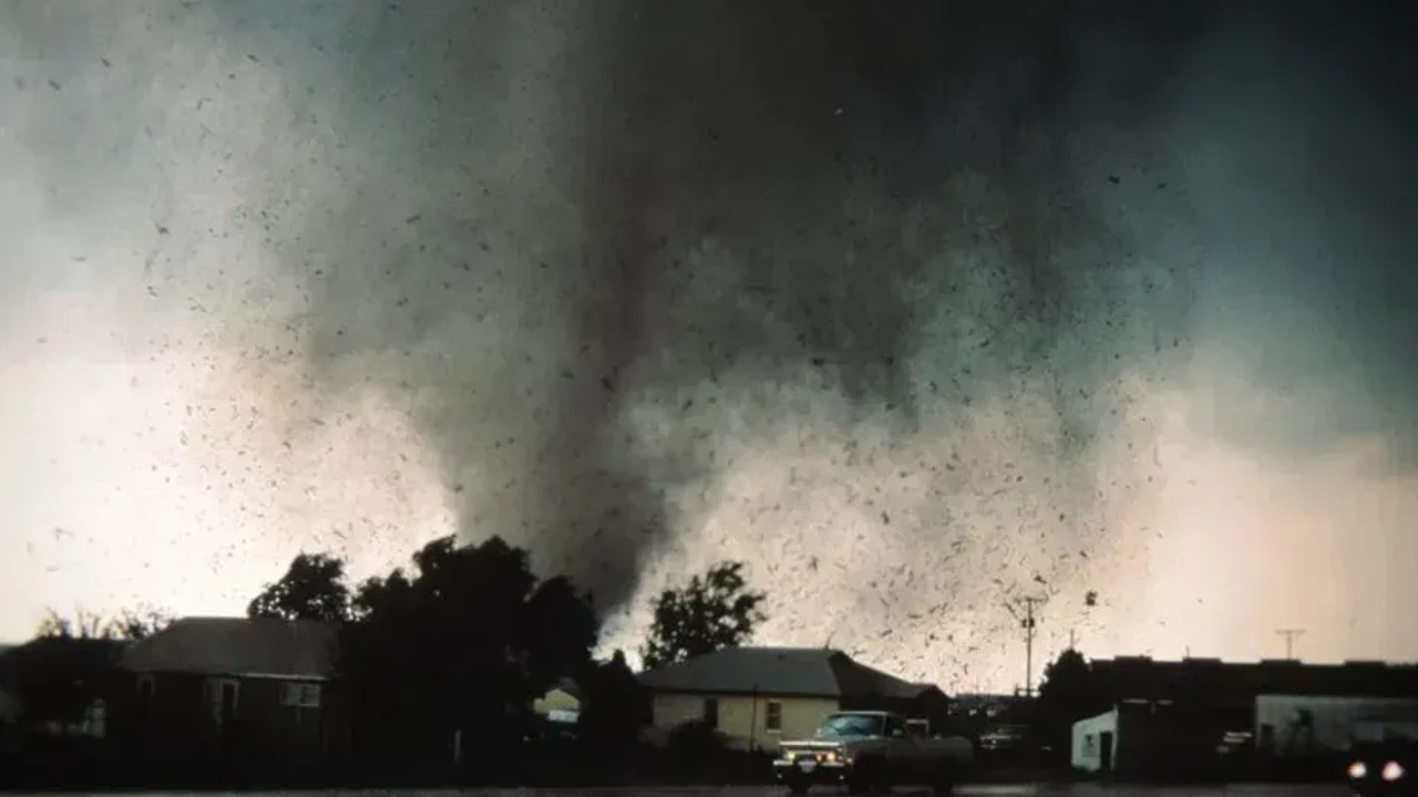
Pampa Tornado (4:50-5:05 pm CDT)
- Formed 3 miles southwest of Pampa, Texas, shortly before 5 p.m., dissipating in the city after a 15-minute lifespan.
- Caused F4 damage in Pampa’s industrial area.
- Captured on iconic video by Sheriff Randy Stubblefield, showing a narrow “drillbit” tornado hurling debris at high speeds.
- Photogrammetry by tornado expert Tom Grazulis estimated winds exceeding 300 mph in the lower funnel.
Hoover Tornado (4:59-5:34 pm CDT)
- Emerged northeast of Pampa while the Pampa tornado was active.
- Evolved into a large, photogenic stovepipe tornado, famously videoed by Martin Lisius near the Rufe Jordan Prison Unit.
- Officially rated F2, but scoured asphalt—a hallmark of the most violent (F4/F5) tornadoes—suggesting it was underrated.
McLean-Kellerville Area Tornadoes (5:52 pm-7:52 pm CDT)
- A new supercell southwest of McLean produced multiple tornadoes, observed by veteran chaser Bruce Haynie.
- The first tornado, rated EF2, reportedly wiped a house off its foundation and damaged the concrete slab, rivaling the destruction of the 2011 Smithville, Mississippi, tornado. This damage was allegedly underreported by the National Weather Service.
- The next major tornado in that area, a violent multiple-vortex tornado, crossed Highway 273, scouring asphalt and morphing into a stovepipe. The VORTEX project, arriving late after targeting a different storm, documented its peak intensity, noting extreme vegetation damage and ground scouring. Rated F4, some scientists argued it warranted an F5.
Allison Tornado (~8:00-8:30 pm CDT)
- Formed southwest of Allison, Texas, this tornado reached a width of at least 1 mile, possibly more.
- Caused severe vegetation damage, earning an F4 rating.
- Near its end, it sharply turned left and accelerated, similar to the 2013 El Reno tornado, highlighting the danger of positioning north of a large, violent tornado.
What Drove This Outbreak?
The atmospheric setup for this event was remarkable, blending subtle and extreme elements:
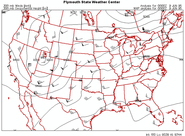
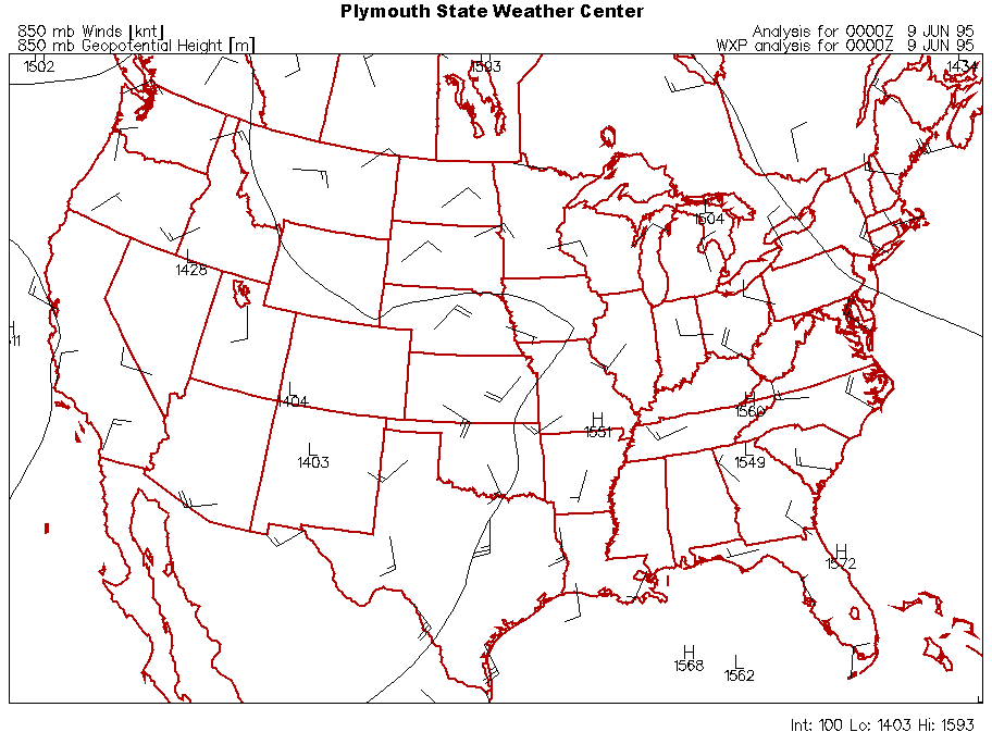
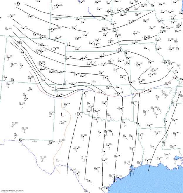
Upper Levels (300 mb): A negatively tilted trough sat over the western U.S., with its axis farther west than typical for outbreaks. This positioned the Texas Panhandle in the right rear quadrant of one jet streak and the left front quadrant of another, creating a “coupled jet” effect that drove strong upward motion.
Mid-Levels (500 mb): West-southwesterly flow around 40 knots—sufficient for strong supercells but not extreme. Lift from mid-level spin was displaced northward.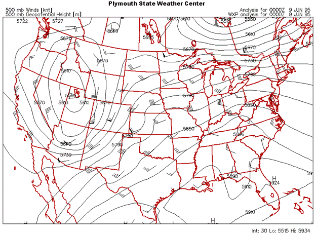
Low Levels (850 mb): Winds around 30 knots, slightly below average for outbreaks, but strengthened as the nocturnal low-level jet developed, enhancing low-level shear.
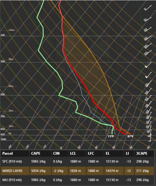
Instability: Massive, with CAPE exceeding 5,000 J/kg, driven by steep lapse rates and high dewpoints (~73°F), extraordinary for the elevated Texas Panhandle.
Three Conditions for Violent Tornado Outbreaks
To spot a setup like June 8, 1995, look for:
- Moderate Mid-Level Flow: Deep-layer shear sufficient for supercells (e.g., 500 mb winds >30 knots, ideally ~40 knots).
- Strong Low-Level Flow: Adequate low-level shear, ideally 850 mb winds ~40 knots or higher, with a southerly component.
- Extreme Instability: High CAPE (e.g., >5,000 J/kg) from steep lapse rates and high dewpoints. The more extreme, the better.
Takeaway for Chasers
If you see a forecast with these three ingredients—moderate mid-level flow, strong low-level shear, and extreme instability—don’t hesitate. Grab your gear and chase. This combination fueled one of the most violent tornado outbreaks in history, and it could do so again.
The Tornado Chaser Transformation

If you’re looking to deepen your tornado chasing skills, The Tornado Chaser Transformation is available now. This 6-hour course distills my years of experience—meteorology, chasing techniques, and safety insights—to guide you further, whether you’re just starting or seeking to refine your craft. Find it at https://www.gabegarfield.com/tct whenever you’re ready to explore more.
