Does History Repeat Itself? Comparing Two Plains Tornado Outbreaks
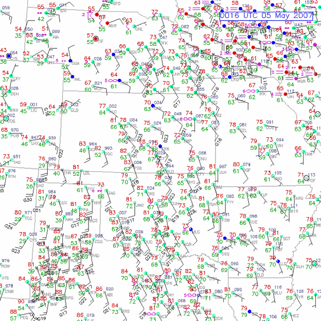
On May 4, 2007, one of the most infamous tornado events in storm-chasing history unfolded in Kansas. The small town of Greensburg was devastated by a nearly two-mile-wide tornado, destroying 90% of the town.

This was the first tornado rated EF5 on the Enhanced Fujita scale. It killed 12 people and injured 63. From a chaser's perspective, the event's most remarkable feature was the sheer number of large, violent tornadoes produced by the parent supercell.
After striking Greensburg, the storm spawned three more massive tornadoes, two of which—the Trousdale and Hopewell wedges—occurred simultaneously. The Trousdale tornado reached 2.2 miles wide, while Hopewell was 1.2 miles wide. For comparison, even the violent Pilger twin tornadoes on June 16, 2014, paled in scale next to this pair. In total, the storm produced at least 22 tornadoes over six hours.
To me, this was one of the greatest supercells of all time. While there may have been larger outbreaks, the Greensburg storm stood unmatched. It seemed like a once-in-a-lifetime event—that is, until May 18, 2025.
A Strikingly Similar Setup
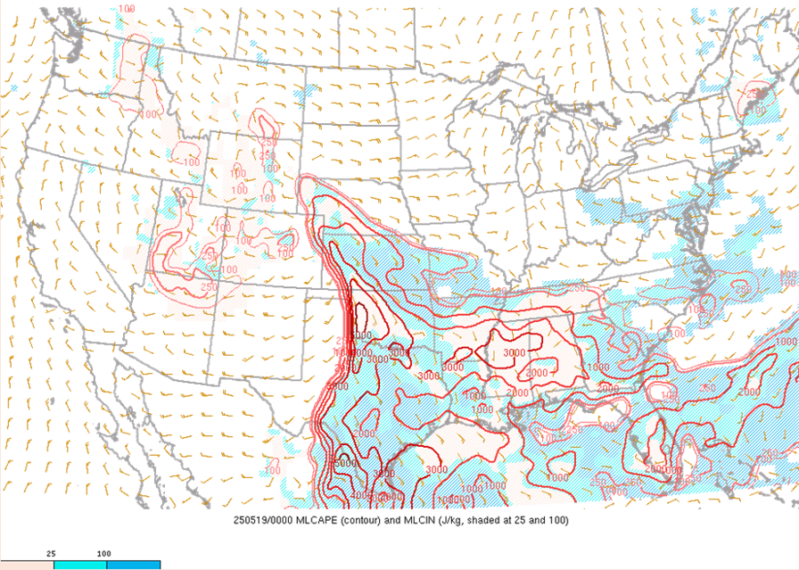
On paper, the 2025 setup mirrored 2007: a strong, negatively tilted upper trough advancing into the Plains around peak heating, with dew points in the upper 60s to low 70s.
But, like many seasoned chasers, I'm skeptical of "analogs"—the practice of comparing upcoming weather patterns to past events for predictions. For those unfamiliar, analogs involve matching forecast charts to historical ones from major tornado outbreaks, assuming similar patterns yield similar results. This approach underpinned the first tornado forecast in March 1948. A strong tornado struck Tinker Air Force Base Oklahoma City on March 20th.
Five days later, meteorologists Ernest Fawbush and Robert Miller noticed eerie similarities in the weather charts. They issued a tornado warning before storms even formed, prompting the base to shelter aircraft. Sure enough, another tornado hit, saving millions in damages. This success laid the foundation for modern tornado warnings, saving countless lives since.
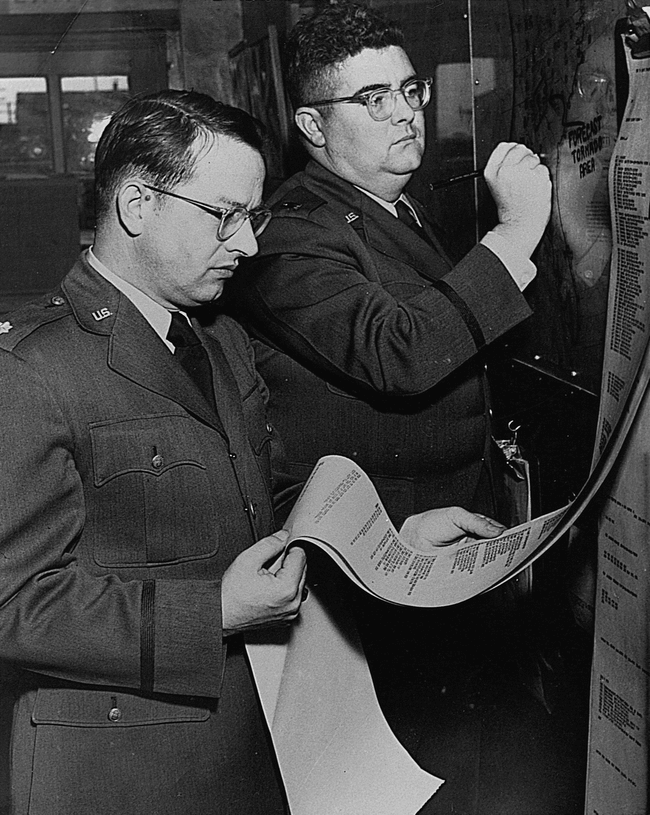
Fawbush and Miller's success highlighted the potential of using pattern recognition as a forecast tool, though outcomes can vary due to factors on a smaller scale. That is, seemingly identical large-scale setups can produce wildly different outcomes. I've learned this the hard way, getting excited about upcoming events based on analogs only to see them fizzle. Yet May 18, 2025 was so similar, it challenged my doubts about these atmospheric doppelgängers. When I saw the forecast for that day, I immediately thought "Greensburg."
My Chase on May 18, 2025
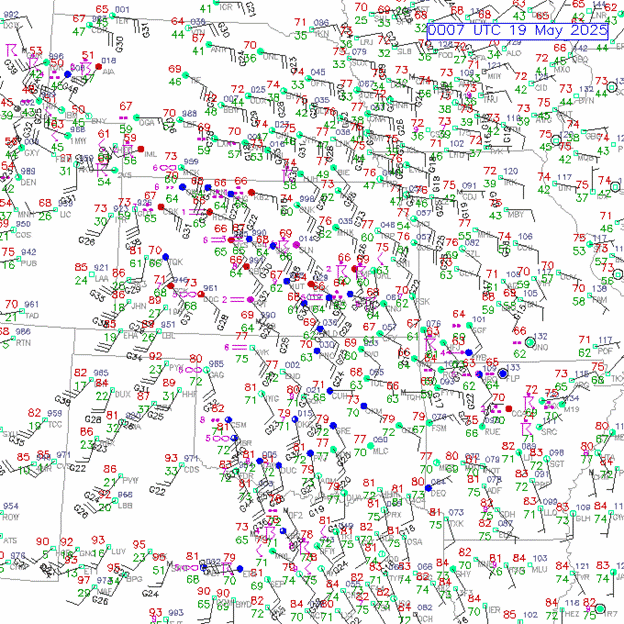
That afternoon, my chase partner Zach Hall and I targeted northwest Oklahoma. Near Arnett, we documented a photogenic EF3 tornado.
After it dissipated, a brief follow-up tornado formed, but the storm weakened under a strong cap (a layer of warm air suppressing storm development).
We pressed on, hoping for regeneration, and spotted a skinny, low-precipitation supercell north of Woodward. But it too was eaten by the cap.
We decided to call it a day in Woodward. But soon, new updrafts formed southwest of Greensburg, Kansas. As we were leaving town, I suggested heading north to check it out. Zach agreed it was tempting, but he needed to return to Arkansas early. With that, we fully closed the door to a night chase.
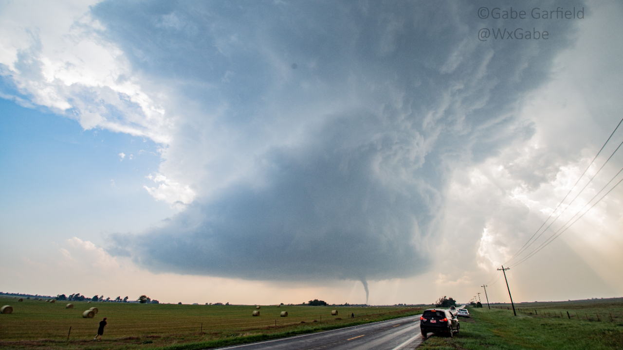
On our way to Oklahoma City, the storm exploded. Within 30 minutes of initiation, it spawned its first tornado southwest of Greensburg around 9:21 p.m. CDT—a half-mile-wide wedge. Only a handful of chasers remained to witness it, but the spectacle was just starting. Obviously, we had made a big mistake.

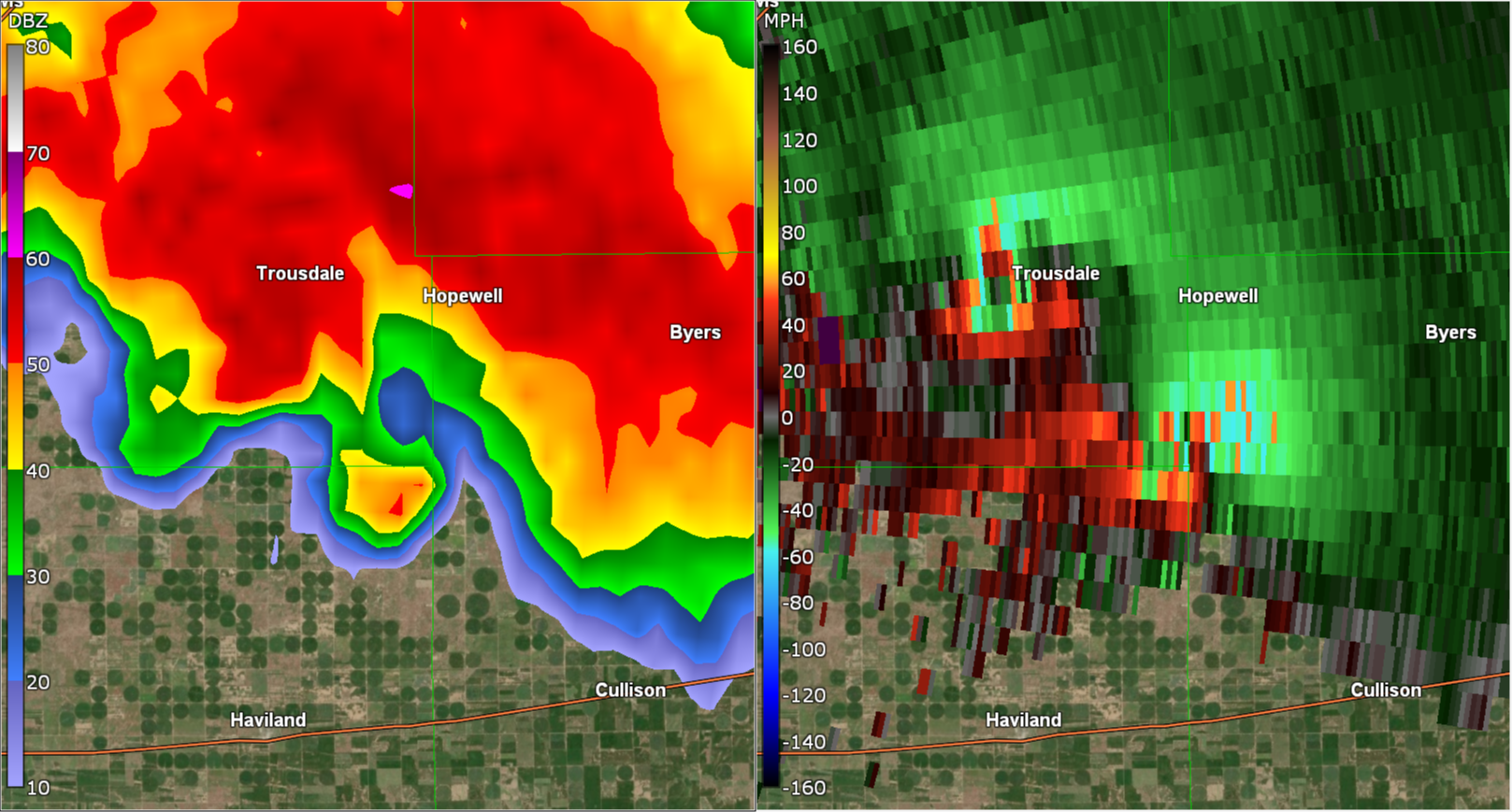
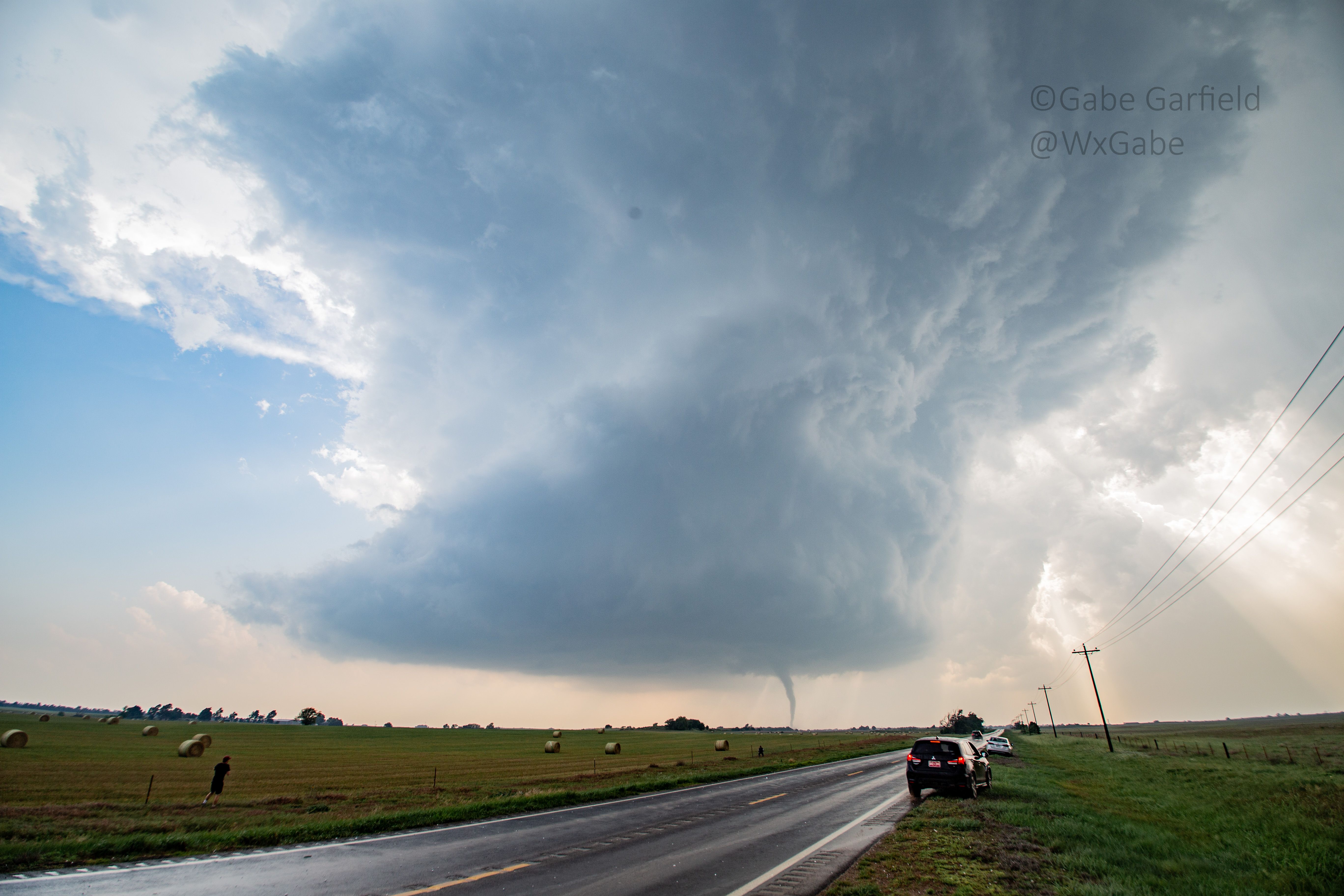
Over the next three hours, the storm produced five more large, intense tornadoes, three of which were about a mile wide. See this striking image of the most menacing one, shot by veteran storm chasers Juston Drake and Simon Brewer:
Large wedge tornado SW of Plevna, KS at approximately 2348 hours. w/@SimonStormRider pic.twitter.com/winib5l8eX
— Juston Drake (@JustonStrmRider) May 19, 2025
This sequence echoed 2007 strikingly: the second 2025 tornado even crossed the original EF5's path. Adding to the parallels, the 2007 event also featured a tall, photogenic-but-powerful tornado near Arnett, Oklahoma. So, just how similar were these outbreaks?
Similarities Between the Events
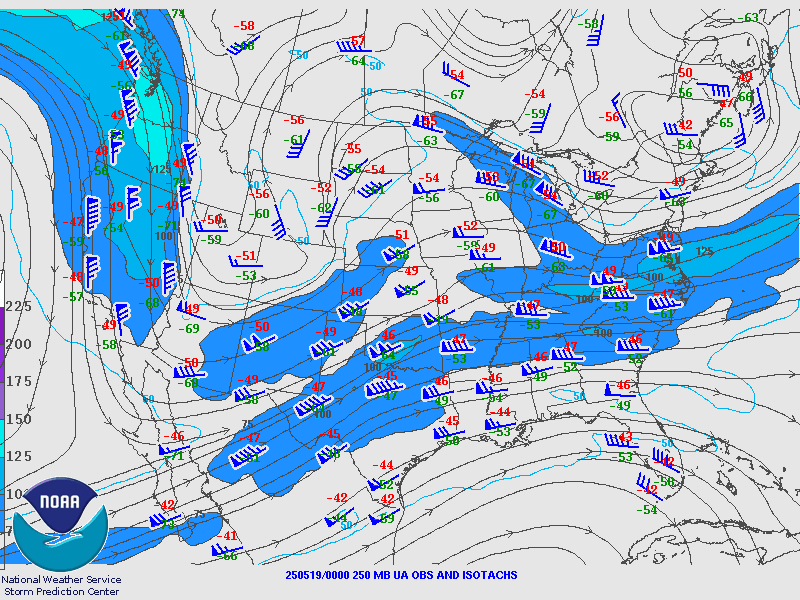
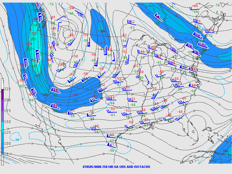
As shown earlier, both days featured an upper-level low-pressure system centered near the Four Corners region, along with a strong jet maximum advancing from the west. In each case, a jet streak arrived in the area around 7 p.m. CDT.

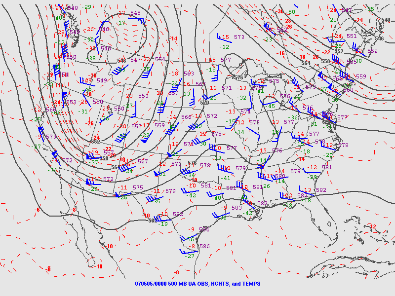
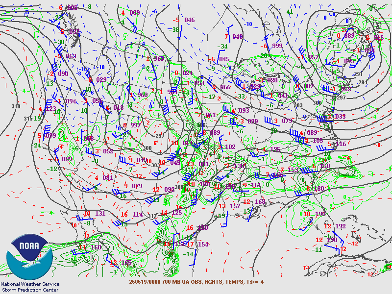
At the 700 mb pressure level, sharp wind speed gradients were present, with speeds exceeding 35 knots.
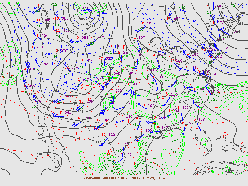
At the surface, winds were backed (coming from the southeast), and dew points ranged from the upper 60s to low 70s Fahrenheit.
Both storm days featured uncapped instability in western Oklahoma, extending into Kansas.
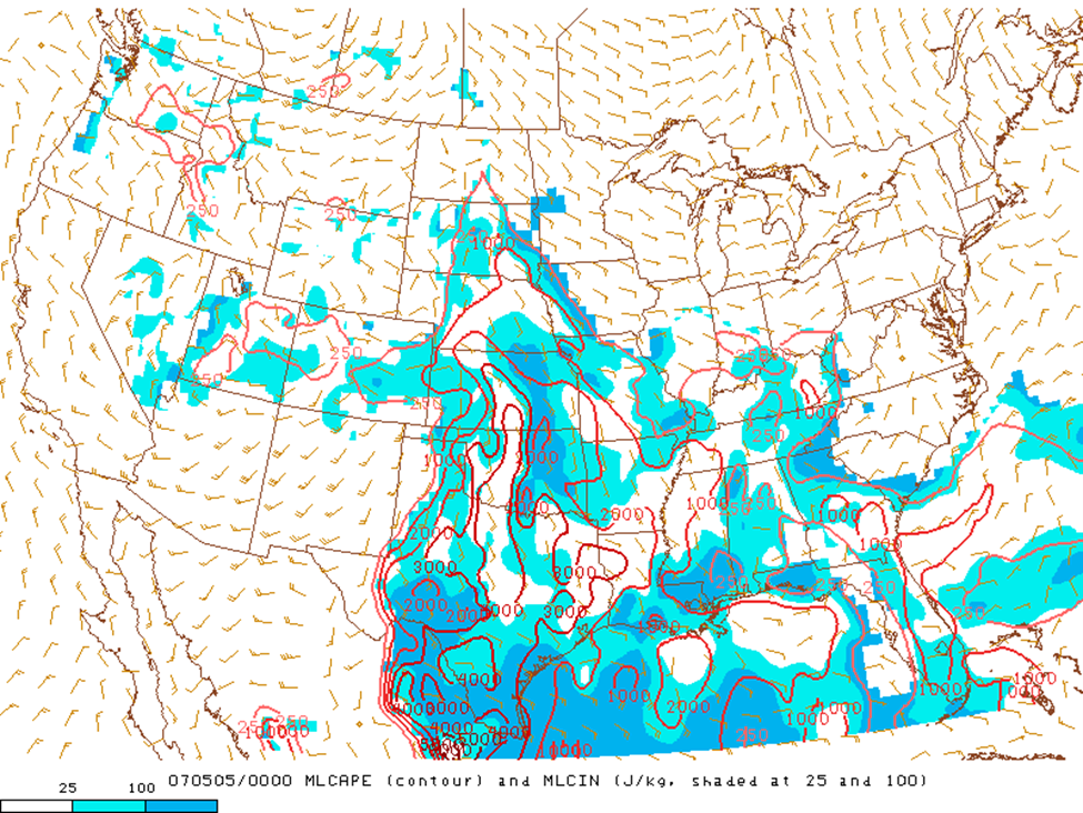
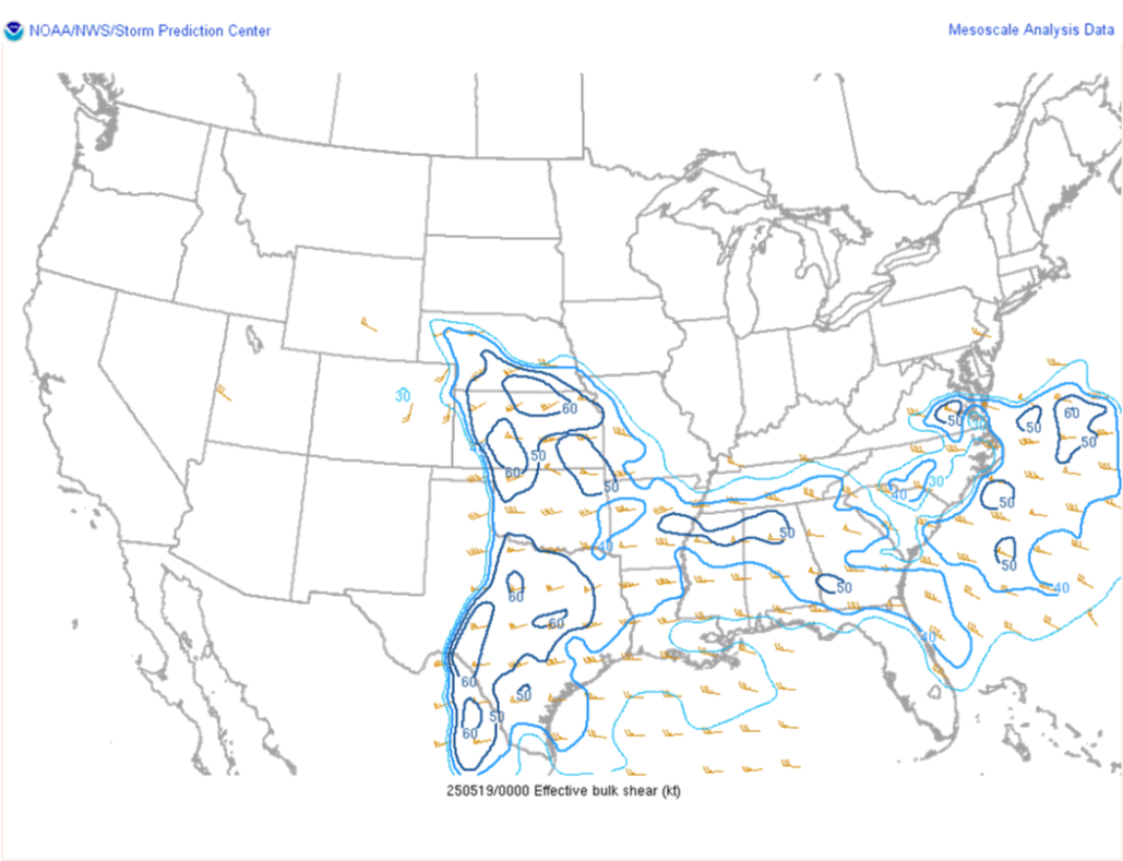
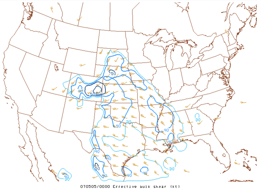
The deep-layer shear was comparable in both events, although the 2025 event exhibited higher magnitude shear due to the earlier arrival of the upper-level jet.
Key Differences
Despite those similarities, there were several important differences between the 2007 and 2025 event. The 2007 upper-level trough was stronger and more amplified, with north-south oriented winds that delayed storm forcing. In 2025, though, it was flatter and more east-west oriented, featuring an earlier jet maximum that accelerated development.
Low-level winds were stronger in 2025, likely due to the earlier jet streak, which created sharper pressure gradients and faster wind speeds. The surface dryline bulge was more pronounced in 2025 as well. This was also due to the early jet arrival, which caused westerly momentum to mix downward during daytime heating. This enhanced dryline convergence, ultimately leading to more storms. Also, convective inhibition, or cap strength, was stronger in 2007 because the jet remained lagged to the west.
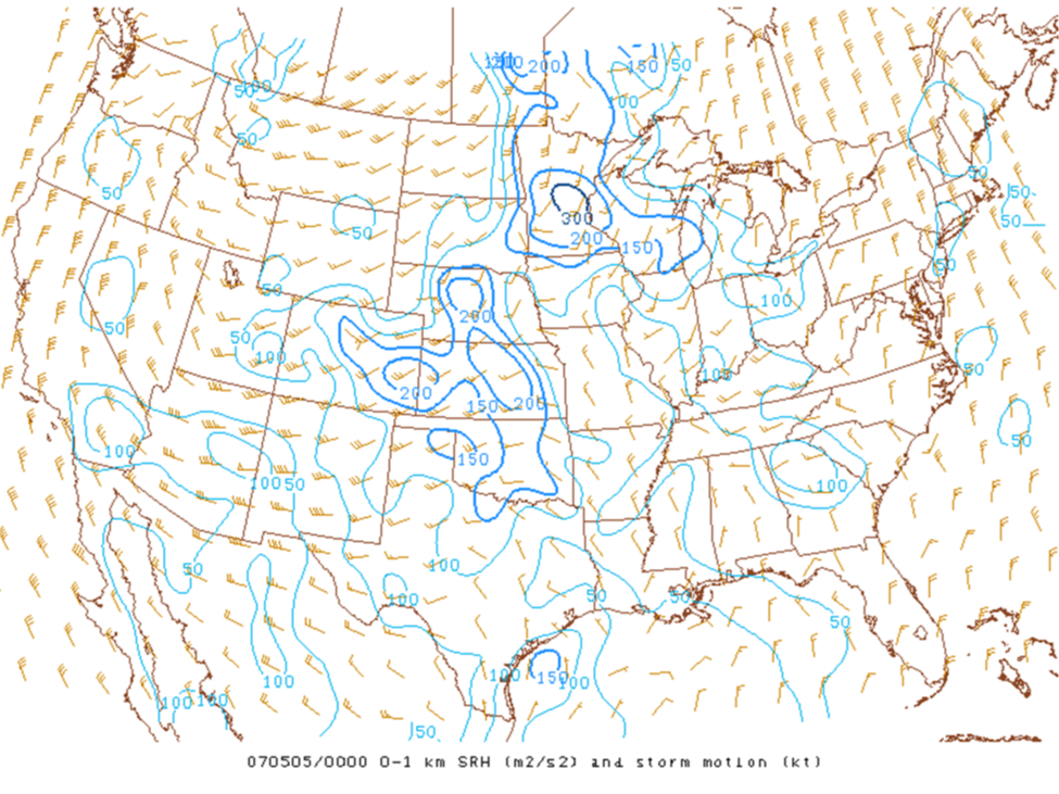
Deep-layer shear was greater in 2025 owing to the earlier arrival of the jet. Finally, low-level shear was significantly stronger on May 18, with 0-1 km storm-relative helicity often exceeding 200 m²/s² and reaching over 300 m²/s² in some areas, compared to around 150 m²/s² on May 4; however, shear did increase later on May 4 as the system approached.
Why the Outcomes Differed
Weaker upper-level lift over the Plains differences explain why 2007 had fewer storms than 2025. The 2025 outbreak was more widespread. Several tornadic supercells formed, arcing from north Texas to southern Nebraska. One of the worst tornadoes of the day hit Grinnell, a small town in northwest Kansas.
Damaging tornado crossed I-70 near Grinnell, now north of Scott City Kansas take shelter immediately! pic.twitter.com/5ZaRgDWZHx
— primalkey (@primalkey) May 19, 2025
Overall, the 2025 environment was superior in deep-layer shear and capping strength. So why was 2007 a little violent?
It's tough to say. But one factor might be the "streamwiseness" of the low-level hodograph. In 2007 (top), near-ground shear was mostly streamwise -- storm-relative winds would drive pure spin into any storm. But in the 2025's Plevna case (bottom), it was partially "crosswise" -- meaning, the lowest 500 m of the hodograph would not "push" much spin into a storm. That said, it's not clear how representative the 7 pm Dodge City sounding was of the later Greensburg and Plevna storms.


Conclusion
While the 2025 Plevna event mirrored Greensburg in many ways, key differences in shear strength and upper-trough timing set them apart. The May 18th outbreak resembled May 4th but featured far more storms. In summary, analogs are a useful starting point, but diagnosing the setup's nuances is crucial for accurate forecasting.
_________
If you're inspired to dive deeper into forecasting techniques and elevate your own storm chasing game—like spotting those subtle atmospheric cues that make or break a chase—check out my online course, The Tornado Chaser Transformation. In just 6 hours, you'll gain 25+ years of proven strategies to chase smarter and safer. Enroll now and start your journey.
_________
